L’articolo è stato aggiunto alla lista dei desideri
LIBRO INGLESE

 E-mail
 Facebook
 LinkedIn
 Twitter
 WhatsApp
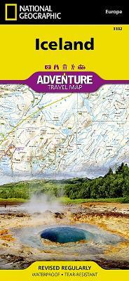
Iceland Map: Adventure Maps
(0)
Cliccando su “Conferma” dichiari che il contenuto da te inserito è conforme alle Condizioni Generali d’Uso del Sito ed alle Linee Guida sui Contenuti Vietati. Puoi rileggere e modificare e successivamente confermare il tuo contenuto. Tra poche ore lo troverai online (in caso contrario verifica la conformità del contenuto alle policy del Sito).
Grazie per la tua recensione!
Tra poche ore la vedrai online (in caso contrario verifica la conformità del testo alle nostre linee guida). Dopo la pubblicazione per te +4 punti ![]()
14,83 €

-5%
15,61 €
+150
punti Prezzo minimo ultimi 30 giorni: 14,65 €
Venditore: IBS
Articolo acquistabile con Carta del Docente

Articolo acquistabile con Carta Cultura Giovani e Carta del Merito

Articolo acquistabile con Carta della Cultura

Dati e Statistiche
 Salvato in 0 liste dei desideri
Iceland Map: Adventure Maps
Attualmente non disponibile
14,83 €
-5%
15,61 €
14,83 €
15,61 €
-5%
Attualmente non disponibile
Altre offerte vendute e spedite dai nostri venditori
Libri in Inglese
Iceland Map: Adventure Maps
Altri venditori
Prezzo e spese di spedizione

Nuovo
Attualmente non disponibile

Venduto e spedito da
IBS
Spedizione Gratis
-5%
15,61 €
14,83 €
Altri venditori
Prezzo e spese di spedizione
Nuovo
Attualmente non disponibile
Venduto e spedito da
IBS
Spedizione Gratis
-5%
15,61 €
14,83 €
Altri venditori
Prezzo e spese di spedizione
Tutti i formati ed edizioni

Promo attive (1)
• Waterproof • Tear-Resistant • Travel MapLet National Geographic's Iceland Adventure Map guide you as you discover the pristine nature and unique scenery on this Nordic island. The expertly researched map, with its accurate and detailed information, is designed to meet the needs of adventure travelers. In addition to a clearly marked road network, with distances and destinations of both major and main roads, the map also delivers an abundance of specialized content not found in traditional road maps. An index of cities and towns will help you arrive at your destination quickly. Recreational, ecological, cultural, and historic points of interest as well as secondary roads, remote tracks, secluded paths and ferry routes will aid in your exploration both on and off the beaten path. Among the pinpointed points of interest are hot springs, geysers, waterfalls, caves, museums, lighthouses, swimming pools, golf courses, campsites and scenic viewpoints. Also labeled are the UNESCO World Heritage Sites, Thingvellir National Park and the volcanic island of Surtsey. The shaded relief map details the entire island, contour lines are drawn, peaks and summits are labeled with elevations, forested areas are shaded, water features are shown and boundaries of National Parks and nature reserves are color-coded, making it the perfect companion to any guidebook. Every Adventure Map is printed on durable synthetic paper, making them waterproof, tear-resistant and tough — capable of withstanding the rigors of international travel.
Leggi di più
Leggi di meno
Autore:
Editore:
Anno:
2011
Rilegatura:
Sheet map, folded
Pagine:
1 p.
Testo in English
Dimensioni:
2300 x 1100 mm
Peso:
100 gr.
EAN:
9781566955348
L'articolo è stato aggiunto al carrello
Informazioni e Contatti sulla Sicurezza dei Prodotti
Le schede prodotto sono aggiornate in conformità al Regolamento UE 988/2023. Laddove ci fossero taluni dati non disponibili per ragioni indipendenti da IBS, vi informiamo che stiamo compiendo ogni ragionevole sforzo per inserirli. Vi invitiamo a controllare periodicamente il sito www.ibs.it per eventuali novità e aggiornamenti.
Per le vendite di prodotti da terze parti, ciascun venditore si assume la piena e diretta responsabilità per la commercializzazione del prodotto e per la sua conformità al Regolamento UE 988/2023, nonché alle normative nazionali ed europee vigenti.
Per informazioni sulla sicurezza dei prodotti, contattare productsafetyibs@feltrinelli.it
L’articolo è stato aggiunto alla lista dei desideri