L’articolo è stato aggiunto alla lista dei desideri

LIBRO INGLESE

 E-mail
 Facebook
 LinkedIn
 Twitter
 WhatsApp
The Skye Trail: A challenging backpacking route from Rubha Hunish to Broadford
(0)
Cliccando su “Conferma” dichiari che il contenuto da te inserito è conforme alle Condizioni Generali d’Uso del Sito ed alle Linee Guida sui Contenuti Vietati. Puoi rileggere e modificare e successivamente confermare il tuo contenuto. Tra poche ore lo troverai online (in caso contrario verifica la conformità del contenuto alle policy del Sito).
Grazie per la tua recensione!
Tra poche ore la vedrai online (in caso contrario verifica la conformità del testo alle nostre linee guida). Dopo la pubblicazione per te +4 punti ![]()
17,76 €

-5%
18,69 €
+180
punti
Venditore: IBS
Articolo acquistabile con Carta del Docente

Articolo acquistabile con Carta Cultura Giovani e Carta del Merito

Articolo acquistabile con Carta della Cultura

Dati e Statistiche
 Salvato in 1 lista dei desideri
The Skye Trail: A challenging backpacking route from Rubha Hunish to Broadford
Disponibile in 5 gg lavorativi
17,76 €
-5%
18,69 €
17,76 €
18,69 €
-5%
Disponibile in 5 gg lavorativi
Altre offerte vendute e spedite dai nostri venditori

Libri in Inglese
The Skye Trail: A challenging backpacking route from Rubha Hunish to Broadford
Altri venditori
Prezzo e spese di spedizione
LIBRO INGLESE
Disponibile in 5 gg lavorativi

Venduto e spedito da
IBS
Spedizione Gratis
-5%
18,69 €
17,76 €
Altri venditori
Prezzo e spese di spedizione
LIBRO INGLESE
Disponibile in 5 gg lavorativi
Venduto e spedito da
IBS
Spedizione Gratis
-5%
18,69 €
17,76 €
Altri venditori
Prezzo e spese di spedizione
Tutti i formati ed edizioni

Promo attive (0)
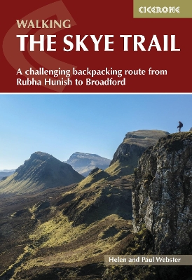
Guidebook to the Skye Trail, a challenging 80-mile (128km) trek that snakes its way north–south across the Isle of Skye. This unofficial, week-long route is ideal for backpacking, camping wild each night, but can also be walked between overnight accommodation. Unwaymarked route on sometimes pathless terrain requires navigational skill, fitness and self-reliance, so is suitable for experienced mountain walkers Seven daily stages of 7–18 miles (11–29km) in length, with an optional 6-mile (11km) alternative route via the summit of Bla Bheinn, one of Skye’s most spectacular Munros Starts at Rubha Hunish at the northern tip of Skye, visits the capital Portree, follows Glen Sligachan between the Black Cuillin and Red Hills, before finishing in the south at Broadford Highlights include the Trotternish Ridge, the Quiraing, the Old Man of Storr, the mighty Cuillin and the abandoned village of Boreraig Clear route descriptions with full 1:50,000 OS mapping and elevation profiles for hillier stages Includes details of refreshments, public transport and accommodation, notes on geology, history, plants and wildlife, and a glossary of Gaelic place names
Leggi di più
Leggi di meno
Autore:
Editore:
Anno:
2023
Rilegatura:
Paperback / softback
Pagine:
112 p.
Testo in English
Dimensioni:
172 x 116 mm
Peso:
130 gr.
EAN:
9781786311863
L'articolo è stato aggiunto al carrello
Informazioni e Contatti sulla Sicurezza dei Prodotti
Le schede prodotto sono aggiornate in conformità al Regolamento UE 988/2023. Laddove ci fossero taluni dati non disponibili per ragioni indipendenti da IBS, vi informiamo che stiamo compiendo ogni ragionevole sforzo per inserirli. Vi invitiamo a controllare periodicamente il sito www.ibs.it per eventuali novità e aggiornamenti.
Per le vendite di prodotti da terze parti, ciascun venditore si assume la piena e diretta responsabilità per la commercializzazione del prodotto e per la sua conformità al Regolamento UE 988/2023, nonché alle normative nazionali ed europee vigenti.
Per informazioni sulla sicurezza dei prodotti, contattare productsafetyibs@feltrinelli.it
L’articolo è stato aggiunto alla lista dei desideri