L’articolo è stato aggiunto alla lista dei desideri

LIBRO INGLESE

 E-mail
 Facebook
 LinkedIn
 Twitter
 WhatsApp
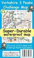
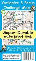
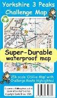
Yorkshire 3 Peaks Challenge Map and Guide
(0)
Cliccando su “Conferma” dichiari che il contenuto da te inserito è conforme alle Condizioni Generali d’Uso del Sito ed alle Linee Guida sui Contenuti Vietati. Puoi rileggere e modificare e successivamente confermare il tuo contenuto. Tra poche ore lo troverai online (in caso contrario verifica la conformità del contenuto alle policy del Sito).
Grazie per la tua recensione!
Tra poche ore la vedrai online (in caso contrario verifica la conformità del testo alle nostre linee guida). Dopo la pubblicazione per te +4 punti ![]()
10,68 €

-5%
11,24 €
+110
punti
Venditore: IBS
Articolo acquistabile con Carta del Docente

Articolo acquistabile con Carta Cultura Giovani e Carta del Merito

Articolo acquistabile con Carta della Cultura

Dati e Statistiche
 Salvato in 0 liste dei desideri
Yorkshire 3 Peaks Challenge Map and Guide
Disponibile in 5 gg lavorativi
10,68 €
-5%
11,24 €
10,68 €
11,24 €
-5%
Disponibile in 5 gg lavorativi
Altre offerte vendute e spedite dai nostri venditori
Libri in Inglese
Yorkshire 3 Peaks Challenge Map and Guide
Altri venditori
Prezzo e spese di spedizione
Nuovo
Disponibile in 5 gg lavorativi

Venduto e spedito da
IBS
Spedizione Gratis
-5%
11,24 €
10,68 €
Altri venditori
Prezzo e spese di spedizione
Nuovo
Disponibile in 5 gg lavorativi
Venduto e spedito da
IBS
Spedizione Gratis
-5%
11,24 €
10,68 €
Altri venditori
Prezzo e spese di spedizione
Tutti i formati ed edizioni
Promo attive (0)
Yorkshire 3 Peaks Challenge Map and Guide at 25k scale with challenge route specially highlighted. We licence OS 50k scale mapping which is then doubled in size to produce a 25k map but the features, text and logos are now doubled in size making them much easier to read under challenge conditions. Y3P 12 Hour Challenge Route is added and specially highlighted so that the route stands out against the OS background map. Then we add the additional detail you might need including the popular Challenge starting points of the Pen Y Ghent Cafe (Horton), Station Inn (Ribblehead) and the Hill Inn (Chapel-le-Dale). Then we add the four parts of our Challenge Guide; 1 Horton to Pen-y-ghent, 2 Pen-y-ghent to Whernside, 3 Whernside to Ingleborough, 4 Ingleborough to Horton. The gps track and 47 waypoints (highlighted on the map) of our Challenge is available as a free gpx file download, and can be used on all gps phone apps and gps units. On the reverse of the map sheet is our Locator Map using OS Opendata showing the location of, and access to, the Yorkshire 3 Peaks Challenge relative to a wide area of England. The result is a double sided 600mm by 600mm map design. We then print the map design on a 100 micron plastic substrate using a special UV curing inks process on the UK's only press capable of using this latest technology. The result is a lightweight map that is both waterproof and tearproof, and fully recyclable, that will survive anything your Yorkshire 3 Peaks Challenge can throw at it and afterwards will fold up like new.
Leggi di più
Leggi di meno
Autore:
Editore:
Anno:
2022
Rilegatura:
Sheet map
Pagine:
30 p.
Testo in English
Dimensioni:
205 x 120 mm
Peso:
40 gr.
EAN:
9781782750765
L'articolo è stato aggiunto al carrello
Informazioni e Contatti sulla Sicurezza dei Prodotti
Le schede prodotto sono aggiornate in conformità al Regolamento UE 988/2023. Laddove ci fossero taluni dati non disponibili per ragioni indipendenti da IBS, vi informiamo che stiamo compiendo ogni ragionevole sforzo per inserirli. Vi invitiamo a controllare periodicamente il sito www.ibs.it per eventuali novità e aggiornamenti.
Per le vendite di prodotti da terze parti, ciascun venditore si assume la piena e diretta responsabilità per la commercializzazione del prodotto e per la sua conformità al Regolamento UE 988/2023, nonché alle normative nazionali ed europee vigenti.
Per informazioni sulla sicurezza dei prodotti, contattare productsafetyibs@feltrinelli.it
L’articolo è stato aggiunto alla lista dei desideri