L’articolo è stato aggiunto alla lista dei desideri
LIBRO INGLESE

 E-mail
 Facebook
 LinkedIn
 Twitter
 WhatsApp
Fehmarn - Ostholstein, hiking, cycling and leisure map 1:30,000, freytag & berndt, WKD 5365
(0)
Cliccando su “Conferma” dichiari che il contenuto da te inserito è conforme alle Condizioni Generali d’Uso del Sito ed alle Linee Guida sui Contenuti Vietati. Puoi rileggere e modificare e successivamente confermare il tuo contenuto. Tra poche ore lo troverai online (in caso contrario verifica la conformità del contenuto alle policy del Sito).
Grazie per la tua recensione!
Tra poche ore la vedrai online (in caso contrario verifica la conformità del testo alle nostre linee guida). Dopo la pubblicazione per te +4 punti ![]()
11,87 €

-5%
12,49 €
+120
punti
Venditore: IBS
Articolo acquistabile con Carta del Docente

Articolo acquistabile con Carta Cultura Giovani e Carta del Merito

Articolo acquistabile con Carta della Cultura

Dati e Statistiche
 Salvato in 0 liste dei desideri
Fehmarn - Ostholstein, hiking, cycling and leisure map 1:30,000, freytag & berndt, WKD 5365
Disponibile in 5 gg lavorativi
11,87 €
-5%
12,49 €
11,87 €
12,49 €
-5%
Disponibile in 5 gg lavorativi
Altre offerte vendute e spedite dai nostri venditori

Libri in Inglese
Fehmarn - Ostholstein, hiking, cycling and leisure map 1:30,000, freytag & berndt, WKD 5365
Altri venditori
Prezzo e spese di spedizione

Nuovo
Disponibile in 5 gg lavorativi

Venduto e spedito da
IBS
Spedizione Gratis
-5%
12,49 €
11,87 €
Altri venditori
Prezzo e spese di spedizione
Nuovo
Disponibile in 5 gg lavorativi
Venduto e spedito da
IBS
Spedizione Gratis
-5%
12,49 €
11,87 €
Altri venditori
Prezzo e spese di spedizione
Tutti i formati ed edizioni

Promo attive (0)
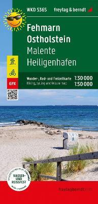
The front of the Fehmarn - Ostholstein hiking, cycling and leisure map shows most of Ostholstein. In addition to the Baltic Coast Cycle Path, numerous regional cycle paths invite you to explore the hilly landscape. The island of Fehmarn is shown on the reverse at a scale of 1:30,000. While the long-distance cycle path follows the course of the coast, regional cycle paths lead through the small towns and over the fields of the island. Information texts on the edge of the map provide information about excursion tips. Information on the hiking and cycling map Fehmarn - Ostholstein Map part Fehmarn: 1:30,000 Map section East Holstein: 1:50,000 hiking trails Cycle and long-distance cycle paths bridle paths GPX-Tracks zum Download Waterproof and tear resistant 99 x 61 cm, printed on both sides Waterproof and tear-resistant The hiking map is printed on a special waterproof and durable paper so that it can also be used for orientation on rainy days. Manufactured in a way that conserves resources The map consists of 80% ground limestone. The production is much more resource-saving than with conventional paper because the consumption of water, wood and energy is significantly lower.
Leggi di più
Leggi di meno
Testo in English
EAN:
9783707920352
L'articolo è stato aggiunto al carrello
Informazioni e Contatti sulla Sicurezza dei Prodotti
Le schede prodotto sono aggiornate in conformità al Regolamento UE 988/2023. Laddove ci fossero taluni dati non disponibili per ragioni indipendenti da IBS, vi informiamo che stiamo compiendo ogni ragionevole sforzo per inserirli. Vi invitiamo a controllare periodicamente il sito www.ibs.it per eventuali novità e aggiornamenti.
Per le vendite di prodotti da terze parti, ciascun venditore si assume la piena e diretta responsabilità per la commercializzazione del prodotto e per la sua conformità al Regolamento UE 988/2023, nonché alle normative nazionali ed europee vigenti.
Per informazioni sulla sicurezza dei prodotti, contattare productsafetyibs@feltrinelli.it
L’articolo è stato aggiunto alla lista dei desideri