L’articolo è stato aggiunto alla lista dei desideri

LIBRO INGLESE

 E-mail
 Facebook
 LinkedIn
 Twitter
 WhatsApp
Alpujarras Tour and Trail Map
(0)
Cliccando su “Conferma” dichiari che il contenuto da te inserito è conforme alle Condizioni Generali d’Uso del Sito ed alle Linee Guida sui Contenuti Vietati. Puoi rileggere e modificare e successivamente confermare il tuo contenuto. Tra poche ore lo troverai online (in caso contrario verifica la conformità del contenuto alle policy del Sito).
Grazie per la tua recensione!
Tra poche ore la vedrai online (in caso contrario verifica la conformità del testo alle nostre linee guida). Dopo la pubblicazione per te +4 punti ![]()
14,66 €

-5%
15,43 €
+150
punti
Venditore: IBS
Articolo acquistabile con Bonus Cultura 18app e Carta del Docente


Articolo acquistabile con Carta Cultura Giovani e Carta del Merito

Dati e Statistiche
 Salvato in 0 liste dei desideri
Alpujarras Tour and Trail Map
Disponibile in 5 giorni lavorativi
14,66 €
-5%
15,43 €
14,66 €
15,43 €
-5%
Disp. in 5 gg lavorativi

Alpujarras Tour and Trail Map
Libri in Inglese
Altri venditori
Prezzo e spese di spedizione

Venduto e spedito da IBS
14,66 €
Spedizione gratuita
Altri venditori
Prezzo e spese di spedizione
Venduto e spedito da IBS
14,66 €
Spedizione gratuita
Altri venditori
Prezzo e spese di spedizione
Tutti i formati ed edizioni

Promo attive (0)
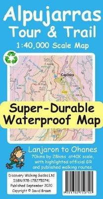
For the best adventures, use the best map. The Moorish white villages of the Alpujarras are well known to day trippers from the Costa del Sol. For walkers this is an idyllic region with stone-laid donkey trails linking the tipico villages and stretching up the southern slopes of the Sierra Nevada to Mulhacen; at 3,483 metres the highest mountain peak on mainland Spain. From Spring to the end of Autumn this is a paradise for hikers, whether you are walking from village to village sampling the local delicacies or tackling the challenging major ascents. One thing you will know is that using the Alpujarras Tour & Trail Map will help you plan, and get the best out of, your adventures. On a large 960mm by 700mm, double sided, map sheet at 40k scale this map has all the detail you need including 20 and 100 metre contours, combined with altitude shading, giving you a true feel to this impressive landscape stretching from west of Lanjaron to Ohanes in the east taking in the Poqueira and Trevelez valleys, while going north to include Mulhacen and Veleta mountain peaks along with the Sierra Nevada ski area. The GR240, GR142 & GR7 (official long distance hiking routes) are specially highlighted (in green) along with all the walking routes from Walk! the Alpujarras guidebook (in red). Our new edition Alpujarras Tour & Trail Map covers an area of 70 kms (E-W) by 28 kms (N-S); more than twice the land area of our earlier editions. A special 'Concertina Map Fold' makes Tour & Trail Maps easy to use, and more importantly easy to fold back to their handy pocket size. Digital editions of Alpujarras Tour & Trail Map are available for phone apps by Viewranger/OutdoorActive and LocusMap. A digital edition of Alpujarras Tour & Trail Custom Map for Garmin users is available as a free digital download from Discovery Walking Guides website. Alpujarras Tour & Trail Custom Map can be loaded into Garmin gps units, and used in Garmin Basecamp and Google Earth. Tour & Trail Super-Durable Maps are printed on a specially finished plastic substrate using special inks which produces a lightweight map that feels like silk while being both water-proof and incredibly tough so that after even the toughest of adventures your Tour & Trail Super-Durable Map will fold up like new. Super-Durable Maps come with a 2 year adventurous use wear and tear guarantee. All the materials used for this map are 100% recyclable in category 2 HDPE.
Leggi di più
Leggi di meno
Autore:
Editore:
Anno:
2020
Rilegatura:
Sheet map
Pagine:
2 p.
Testo in English
Dimensioni:
230 x 120 mm
Peso:
60 gr.
EAN:
9781782750741
L'articolo è stato aggiunto al carrello
L’articolo è stato aggiunto alla lista dei desideri