L’articolo è stato aggiunto alla lista dei desideri

LIBRO INGLESE

 E-mail
 Facebook
 LinkedIn
 Twitter
 WhatsApp
Canada West: Travel Maps International Adventure Map
(0)
Cliccando su “Conferma” dichiari che il contenuto da te inserito è conforme alle Condizioni Generali d’Uso del Sito ed alle Linee Guida sui Contenuti Vietati. Puoi rileggere e modificare e successivamente confermare il tuo contenuto. Tra poche ore lo troverai online (in caso contrario verifica la conformità del contenuto alle policy del Sito).
Grazie per la tua recensione!
Tra poche ore la vedrai online (in caso contrario verifica la conformità del testo alle nostre linee guida). Dopo la pubblicazione per te +4 punti ![]()
16,00 €

-5%
16,84 €
+160
punti Prezzo minimo ultimi 30 giorni: 15,99 €
Venditore: IBS
Articolo acquistabile con Bonus Cultura 18app e Carta del Docente


Articolo acquistabile con Carta Cultura Giovani e Carta del Merito

Dati e Statistiche
 Salvato in 2 liste dei desideri
Canada West: Travel Maps International Adventure Map
Disponibile in 3 settimane
16,00 €
-5%
16,84 €
16,00 €
16,84 €
-5%
Disp. in 3 settimane

Canada West: Travel Maps International Adventure Map
Libri in Inglese
Altri venditori
Prezzo e spese di spedizione

Venduto e spedito da IBS
16,00 €
Spedizione gratuita
Altri venditori
Prezzo e spese di spedizione
Venduto e spedito da IBS
16,00 €
Spedizione gratuita
Altri venditori
Prezzo e spese di spedizione
Tutti i formati ed edizioni

Promo attive (0)
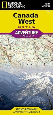
National Geographic's Canada West Adventure Map is designed to meet the needs of adventure travelers with its durability and detailed, accurate information. The map includes the locations of cities and towns with a user-friendly index, a clearly marked road network complete with distances and designations for roads/highways, plus secondary routes for those seeking to explore off the beaten path in and around the Rocky Mountain National Park of Banff, the Yukon Territories, Alberta, Vancouver Island, and the Pacific Shores. Adventure Maps differ from a traditional road map because of the specialty content they include. Each map contains hundreds of diverse and unique recreational, ecological, cultural, and historic destinations - outside of the major tourist hubs. Search for whales off the coast of Vancouver, ski the trails of Whistler, paddle the epic South Nahanni River as it tumbles through the jagged Mackenzie Mountains and the Nahanni National Park Reserve, a World Heritage-listed site. National Geographic Adventure Maps are the perfect companion to a guidebook, yet far easier to pack!Your side one adventure begins at Victoria Island, Nanavut, the Great Slave Lake, the Northwest Territories, Yukon Plateau, Great Bear Lake and Prince Albert Sound. Flip over and the backside showcases the topographic features of Vancouver and Queen Charlotte Islands, the Coast Mountains, British Columbia, the Rocky Mountains, and Alberta. The Canada West Adventure Map is printed in the United States on a durable synthetic paper, making it waterproof, tear-resistant, and capable of withstanding the rigors of international travel. The map is two-sided and is folded to a packable size of 235 x 108 mm; unfolded size is 965 x 660 mm. Travel Tip! Due to the synthetic sheet that Adventure Maps are printed on, you can easily fold the map to a discreet size, showing just the area you're interested in. Key Features:* Waterproof and tear-resistant* Designed and printed in the U. S. A.* Detailed topography with clearly labeled natural features* Major road networks* Hundreds of points of interest, including the location of nature reserves and national parks* Thousands of place names with a detailed index* Important travel aids including airports, rail lines, and other infrastructure* Latitude/Longitude and UTM grids along with a compass rose and scale bars for accurate navigation with compass or GPS
Leggi di più
Leggi di meno
Autore:
Editore:
Anno:
2013
Rilegatura:
Sheet map, folded
Pagine:
1 p.
Testo in English
Dimensioni:
235 x 108 mm
Peso:
93 gr.
EAN:
9781566956352
L'articolo è stato aggiunto al carrello
L’articolo è stato aggiunto alla lista dei desideri