L’articolo è stato aggiunto alla lista dei desideri

LIBRO INGLESE

 E-mail
 Facebook
 LinkedIn
 Twitter
 WhatsApp
Edale Skyline Challenge Map
(0)
Cliccando su “Conferma” dichiari che il contenuto da te inserito è conforme alle Condizioni Generali d’Uso del Sito ed alle Linee Guida sui Contenuti Vietati. Puoi rileggere e modificare e successivamente confermare il tuo contenuto. Tra poche ore lo troverai online (in caso contrario verifica la conformità del contenuto alle policy del Sito).
Grazie per la tua recensione!
Tra poche ore la vedrai online (in caso contrario verifica la conformità del testo alle nostre linee guida). Dopo la pubblicazione per te +4 punti ![]()
8,30 €

-5%
8,74 €
+80
punti
Venditore: IBS
Articolo acquistabile con Bonus Cultura 18app e Carta del Docente


Articolo acquistabile con Carta Cultura Giovani e Carta del Merito

Dati e Statistiche
 Salvato in 0 liste dei desideri
Edale Skyline Challenge Map
Disponibile in 5 giorni lavorativi
8,30 €
-5%
8,74 €
8,30 €
8,74 €
-5%
Disp. in 5 gg lavorativi

Edale Skyline Challenge Map
Libri in Inglese
Altri venditori
Prezzo e spese di spedizione

Venduto e spedito da IBS
8,30 €
Spedizione gratuita
Altri venditori
Prezzo e spese di spedizione
Venduto e spedito da IBS
8,30 €
Spedizione gratuita
Altri venditori
Prezzo e spese di spedizione
Tutti i formati ed edizioni

Promo attive (0)
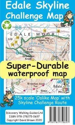
Edale Skyline Challenge is the most scenic of challenge routes thanks to the ridge line nature of its route. At just over 20 miles with a 10 hour challenge time it is suitable for fit leisure walkers as a great day out in good weather; in bad weather it really is a challenge. Free digital app and gps editions included in your purchase To produce our Edale Skyline Challenge Map first we licence Ordnance Survey 50k scale mapping. Then we double it in size to produce a 25k map. Now the OS map features, text and logos are doubled in size making for a map with outstanding clarity which is easy to read under challenge conditions. The Skyline Challenge Route, with its options, are added and specially highlighted so that the challenge route stands out against the OS background map. Then we add any additional detail you might need. The result is a 600mm by 400mm 25k scale map with outstanding clarity and durability. Our special concertina map fold means the map is easy to unfold and to refold to its pocketable 200mm by 120mm folded size. On the reverse of the map sheet we present our detailed Challenge Route description complete with distances and timings for the sections of the route along with the 44 waypoints which define the challenge. We then print the map design on a 100 micron plastic substrate using a special UV curing inks process on the UK's only press capable of using this latest technology. The result is a lightweight map that is both waterproof and tearproof, and fully recyclable, that will survive anything your Challenge can throw at it and afterwards will fold up like new. In addition to our printed Challenge Map we offer you a choice of free digital editions for use with Viewranger and Locus apps and Garmin software and gps units (including Google Earth). We also include the gpx waypoint file for the 44 waypoints in our detailed route description. See the information on the reverse of the map for details of how to download your free digital edition map and gpx waypoint file. After downloading you will have the complete package of Edale Skyline Challenge Map, choice of digital edition Map and gpx file of the waypoints to aid your navigation.
Leggi di più
Leggi di meno
Autore:
Editore:
Anno:
2020
Rilegatura:
Sheet map
Pagine:
2 p.
Testo in English
Dimensioni:
200 x 120 mm
Peso:
40 gr.
EAN:
9781782750697
L'articolo è stato aggiunto al carrello
L’articolo è stato aggiunto alla lista dei desideri