L’articolo è stato aggiunto alla lista dei desideri


LIBRO INGLESE

 E-mail
 Facebook
 LinkedIn
 Twitter
 WhatsApp
Rutland Water Challenge Map and Guide
(0)
Cliccando su “Conferma” dichiari che il contenuto da te inserito è conforme alle Condizioni Generali d’Uso del Sito ed alle Linee Guida sui Contenuti Vietati. Puoi rileggere e modificare e successivamente confermare il tuo contenuto. Tra poche ore lo troverai online (in caso contrario verifica la conformità del contenuto alle policy del Sito).
Grazie per la tua recensione!
Tra poche ore la vedrai online (in caso contrario verifica la conformità del testo alle nostre linee guida). Dopo la pubblicazione per te +4 punti ![]()
10,84 €

-5%
11,41 €
+110
punti
Venditore: IBS
Articolo acquistabile con Bonus Cultura 18app e Carta del Docente


Articolo acquistabile con Carta Cultura Giovani e Carta del Merito

Dati e Statistiche
 Salvato in 0 liste dei desideri
Rutland Water Challenge Map and Guide
Disponibile in 5 giorni lavorativi
10,84 €
-5%
11,41 €
10,84 €
11,41 €
-5%
Disp. in 5 gg lavorativi

Rutland Water Challenge Map and Guide
Libri in Inglese
Altri venditori
Prezzo e spese di spedizione

Venduto e spedito da IBS
10,84 €
Spedizione gratuita
Altri venditori
Prezzo e spese di spedizione
Venduto e spedito da IBS
10,84 €
Spedizione gratuita
Altri venditori
Prezzo e spese di spedizione
Tutti i formati ed edizioni
Promo attive (0)
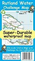
Rutland Water is the UK's largest man-made lake set in 4,200 acres of parkland including a wide, hard surfaced, walkway making the 'Water' an ideal introduction to long distance walking. There are four official, family friendly, recreation centres and nature reserves including the Rutland Osprey Project. Add in picturesque villages and the town of Oakham and you will soon understand why Rutland Water has become one of England's favourite 'Daycation' destinations. Rutland Water Challenge Map and Guide is a 25k scale OSlike map with the Challenge route specially highlighted. We licence OS 50k scale mapping which is then doubled in size to produce an OSlike 25k map but the features, text and logos are now doubled in size making them much easier to read under Challenge conditions. Rutland Water Challenge Route is added and specially highlighted so that our route stands out against the OSlike 25k map. Then we add the additional detail you might need including local hostelries along with the three walking routes; Hambleton Peninsula 8.3kms, Circular 24.5kms and the full Challenge route at 36kms. For each of the three routes we have gps track and waypoints as a gpx file; the zip file of the gpx files is available as a free download. These gps track and waypoints gpx files can be used on all gps phone apps and gps units. The 33 waypoints of the full Challenge route are highlighted on the map, and our Rutland Water Challenge Map is available as a free digital Custom Map download for Garmin gps users. On the reverse of the map sheet is our Locator Map using OS Opendata showing the location of, and access to, Rutland Water relative to a wide area of England. The result is a double sided 600mm by 600mm map design. We then print the map design on a 100 micron plastic substrate using a special UV curing inks process on the UK's only press capable of using this latest technology. The result is a lightweight map that is both waterproof and tearproof, and fully recyclable, that will survive anything your Rutland Water Challenge can throw at it and afterwards will fold up like new.
Leggi di più
Leggi di meno
Autore:
Editore:
Anno:
2022
Rilegatura:
Sheet map
Pagine:
30 p.
Testo in English
Dimensioni:
220 x 120 mm
Peso:
50 gr.
EAN:
9781782750833
L'articolo è stato aggiunto al carrello
L’articolo è stato aggiunto alla lista dei desideri