L’articolo è stato aggiunto alla lista dei desideri


LIBRO INGLESE

 E-mail
 Facebook
 LinkedIn
 Twitter
 WhatsApp
Tour du Mont Blanc Map Guide
(0)
Cliccando su “Conferma” dichiari che il contenuto da te inserito è conforme alle Condizioni Generali d’Uso del Sito ed alle Linee Guida sui Contenuti Vietati. Puoi rileggere e modificare e successivamente confermare il tuo contenuto. Tra poche ore lo troverai online (in caso contrario verifica la conformità del contenuto alle policy del Sito).
Grazie per la tua recensione!
Tra poche ore la vedrai online (in caso contrario verifica la conformità del testo alle nostre linee guida). Dopo la pubblicazione per te +4 punti ![]()
17,76 €

-5%
18,69 €
+180
punti
Venditore: IBS
Articolo acquistabile con Carta del Docente

Articolo acquistabile con Carta Cultura Giovani e Carta del Merito

Dati e Statistiche
 Salvato in 0 liste dei desideri
Tour du Mont Blanc Map Guide
Disponibilità in 5 giorni lavorativi
17,76 €
-5%
18,69 €
17,76 €
18,69 €
-5%
Disp. in 5 gg lavorativi
Altre offerte vendute e spedite dai nostri venditori

Libri in Inglese
Tour du Mont Blanc Map Guide
Altri venditori
Prezzo e spese di spedizione
Nuovo
 disponibilità in 5 giorni lavorativi
 Venduto e spedito da
IBS
Venduto e spedito da
IBS
Spedizione Gratis
-5%
18,69 €
17,76 €
Altri venditori
Prezzo e spese di spedizione
Nuovo
disponibilità in 5 giorni lavorativi
Venduto e spedito da
IBS
Spedizione Gratis
-5%
18,69 €
17,76 €
Altri venditori
Prezzo e spese di spedizione
Tutti i formati ed edizioni

Promo attive (1)
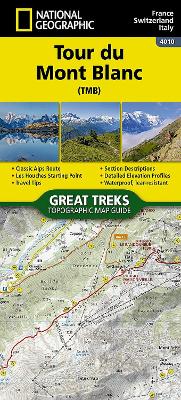
• Waterproof • Tear-Resistant • Topographic Map Located in the northwetern Alps, between the Aosta Valley and Haute-Savoie, Mont Blanc is the highest mountain in Europe at 4,808 meters (15,774 feet). The central part of the Mont Blanc Massif, always snow-covered, consists of a mountain range that crosses Italy, France, and Switzerland. The Tour du Mont-Blanc (TMB) runs counterclockwise with start and finish in Les Houches, France. It covers approximately 170 km with clear signage, a 10,000-meter elevation gain (positive and negative), and takes 10 to 12 days to walk passing through France, Switzerland, and Italy. Travelers will have a chance to admire the spectacular landscapes: vast glacier areas, meadows rich in diverse flora, fascinating lunar-like rock landscapes, alpine pastures, charming villages, and refuges offering a comfortable place to rest The Tour du Mont-Blanc Topographic Map Guide booklet makes a perfect traveling companion when traversing this famous routes. A detailed description of each trail section is included that tells travelers about the many landmarks encountered along the way. Every Great Treks map is printed on "Backcountry Tough" waterproof, tear-resistant paper. A full Lat/Long grid is printed on the map to aid with GPS navigation. Every map purchase helps support the National Geographic Society, an impact driven, nonprofit organization with global reach that uses the power of science, exploration, education, and storytelling to illuminate and protect the wonder of our world. Map Scale = 1:50,000 Folded Size = 4.25" x 9.38"
Leggi di più
Leggi di meno
Autore:
Editore:
Collana:
Great Treks of the World Map Guides
Anno:
2025
Rilegatura:
Sheet map, folded
Pagine:
48 p.
Testo in English
EAN:
9781566959544
L'articolo è stato aggiunto al carrello
Informazioni e Contatti sulla Sicurezza dei Prodotti
Le schede prodotto sono aggiornate in conformità al Regolamento UE 988/2023. Laddove ci fossero taluni dati non disponibili per ragioni indipendenti da IBS, vi informiamo che stiamo compiendo ogni ragionevole sforzo per inserirli. Vi invitiamo a controllare periodicamente il sito www.ibs.it per eventuali novità e aggiornamenti.
Per le vendite di prodotti da terze parti, ciascun venditore si assume la piena e diretta responsabilità per la commercializzazione del prodotto e per la sua conformità al Regolamento UE 988/2023, nonché alle normative nazionali ed europee vigenti.
Per informazioni sulla sicurezza dei prodotti, contattare productsafetyibs@feltrinelli.it
L’articolo è stato aggiunto alla lista dei desideri